
Our Projects
Here, we highlight some of our initiatives to conserve and enhance the unique habitats of the Saline River Watershed. Our projects promote sustainability, recreational opportunities, and the area's scenic beauty.
Travis Zuber Project - Currently awaiting funding sources
The project site is an actively eroding streambank on the right descending bank. There are two areas of erosion on this farm. The upstream portion is 362 feet long with a 15 foot tall vertical bank and the downstream portion is 927 feet long with an average 9 foot tall vertical bank.
-
This property is owned by Travis Zuber and is located on the North Fork Saline River approximately 6 1/2 miles northwest of Benton, Arkansas in Saline County. The project site is an actively eroding streambank on the right descending bank. There are two areas of erosion on this farm. The upstream portion is 362 feet long with a 15 foot tall vertical bank and the downstream portion is 927 feet long with an average 9 foot tall vertical bank. The cause for streambank erosion at this site started from a log jam. Once the log jam got the erosion started, the large trees in the riparian buffer fell in the river and left the hay field unprotected and susceptible to erosion because of the lack of deep roots from large trees, shrubs, and vines. Mr. Zuber has already lost 2.8 acres of landmass by my calculations. If this erosion is allowed to continue, it will compromise the bridge abutments on Steel Bridge road. If the bridge abutments are damaged due to erosion, the Arkansas Department of Transportation (ArDOT) will have to close the bridge resulting in adverse impacts to the local economy due to detoured traffic.
The primary soils are Ouachita silt loam, which are very erodible and frequently flooded. The frequency and magnitude of floods that we have encountered in recent history have caused much of the damage. With each major flood event, literally tons of soil/sediment is sent down the Upper Saline watershed which is home to federally listed threatened Arkansas Fatmucket (Lampsilis powellii), endangered Pink Mucket (Lampsilis abrupta), threatened Rabbitsfoot (Quadrula cylindrica cylindrica), and endangered Winged Mapleleaf (Quadrula fragosa) freshwater mussels. The North Fork Saline River is a state designated Extraordinary Resource Waterbody (ERW), and an Ecologically Sensitive Waterbody (ESW) for the endemic Ouachita Madtom (Noturus lachneri). Also contained within this river is a favorite sportfish for many anglers, the Smallmouth Bass (Micropterus dolomieui).
The recommended methods for stabilizing these eroding stream banks are constructing rock vanes that point upstream in the upstream segment of erosion, removing the remnants of the log jam and constructing a false bank line with longitudinal filled stone toe protection (LFSTP) and tie backs in the lower area of erosion, and replanting native vegetation to re-establish riparian buffers on both sections.
This project is currently awaiting funding sources.


Mike Nalley Project - Currently awaiting funding sources
The project site is an actively eroding streambank on the left descending bank. At the time of the site visit, the area of concern was 1,857 linear feet long with 6-8 foot tall vertical banks.
-
This property is owned by Mike Nalley. The property is located on the Alum Fork Saline River approximately 5 miles northwest of Benton, Arkansas in Saline County. The project site is an actively eroding streambank on the left descending bank. At the time of the site visit, the area of concern was 1,857 linear feet long with 6-8 foot tall vertical banks. The riparian areas on both the left and right descending banks are in good shape with a mixture of age classes of trees, shrubs, vines, and perennial grasses. The land use is primarily forest land and hay production. The soil types are Ouachita silt loam and Carnasaw-Townley association. This area frequently floods.
The primary causes for erosion at this site is from undercutting trees, log jams, an unstable bend in the river, and the frequency and magnitude of flood events in recent years.
Mr. Nalley is losing valuable river front property with each major flood event. Each year several tons of sediment is sent down the Upper Saline watershed due to streambank erosion on Mr. Nalley's property. The Upper Saline watershed is home to federally listed threatened Arkansas Fatmucket (Lampsilis powellii), endangered Pink Mucket (Lampsilis abrupta), and endangered Winged Mapleleaf (Quadrula fragosa) freshwater mussels. The Alum Fork Saline River is a state designated Extraordinary Resource Waterbody and Ecologically Sensitive Waterbody for the endemic Ouachita Madtom (Noturus lachneri). Equally important to the local economy is a favorite sportfish for many anglers, the Smallmouth Bass (Micropterus dolomieui).
The recommended methods for stabilizing this eroding streambank are constructing rock vanes that point upstream and replanting native vegetation on the keys in the riparian area. The rock vanes will direct the flow of water away from the eroded bank back to the center of the stream channel. The flow of water directly upstream of each vane (in the notch of the vane) and downstream of the vane (energy shadow) will slow down and lose its ability to carry materials (sediment) within the water column; therefore depositing it next to the bank in the notch of the rock vanes and below the rock vanes. Over time this area between the vanes will fill in with silt, sediment, and seeds and re-vegetate naturally.
A total of 13 rock vanes will be needed to adequately protect this streambank. The 6 vanes on the upstream portion of the project will be approximately 60 feet long each. The 7 vanes on the downstream portion of the project will be approximately 80 feet long each. Each vane will be keyed into the bank 20 feet for stability and to prevent the structure from being flanked during a flood. The vanes will point upstream at a 30 degree angle from the shoreline. The 60 foot vanes will be approximately 6 feet tall at the streambank and the 80 foot vanes will be approximately 8 feet tall at the streambank. The surface slope of the vane arms will be 10:1. The tip of each vane will be buried into the streambed approximately 3 feet. The largest rocks that are delivered will be used to build the base of the vane and used to construct the tip of the vane. If bedrock is encountered, the tip rocks will be "nailed or pinned" down with 1 inch steel round rod to anchor them in place. Construction will start downstream and work upstream. All rocks will be placed in compression with the flow of water to prevent them from shifting or becoming loose. Locally obtained quarried rock, with a "B" axis ≥ 24 inches, will be used to construct the vanes. Construction will be conducted during low flow conditions..
All bare soil disturbed during construction will be seeded with a cover crop of annual grasses appropriate for the time of year and ecoregion. During the dormant time of year, native trees, shrubs, and grasses will be planted on a 6' x 6' spacing on the keys and high bank and extend out into the flood plain at least 60 feet to re-establish a healthy riparian corridor.
These techniques have worked very well on other similar sites throughout the state. The combination of practices mentioned above will keep the torrent (a.k.a. fast flowing water) off of the eroding bank, reducing near bank shear stress and creating friction to slow flood waters down; reducing velocity on the flood plain and increasing deposition, which ultimately will stop lateral migration due to streambank erosion.
Mike Nalley’s project is currently awaiting funding sources.


Mcneil Creek Trash Trap - Completed 2024
In 2024, the Saline River Watershed Alliance (SRWA) applied for and received a Clean Waterways Grant from Keep Arkansas Beautiful. With this funding, we partnered with Benton Stormwater to install a trash trap in McNeil Creek, a vital step toward reducing pollution in this sensitive watershed.
-
In 2024, the Saline River Watershed Alliance (SRWA) applied for and received a Clean Waterways Grant from Keep Arkansas Beautiful. With this funding, we partnered with Benton Stormwater to install a trash trap in McNeil Creek, a vital step toward reducing pollution in this sensitive watershed.
About McNeil Creek
McNeil Creek is a tributary of the Saline River, flowing through Benton and connecting to one of Arkansas’ most ecologically significant waterways. Unfortunately, roadside litter frequently washes into the creek, posing a threat to local wildlife and water quality. This trash trap is designed to capture floating debris before it continues downstream into the Saline River.
Ongoing Efforts
The SRWA, alongside Saline River Canoe, maintains and cleans the trash trap on a weekly basis—or more frequently following heavy rains. This is an ongoing issue, and we aim to expand our efforts by installing additional trash traps in McNeil Creek and Depot Creek in the near future.
Community Involvement
To further our impact, we hope to partner with local schools, allowing students to earn volunteer hours for graduation while participating in clean-up efforts. Engaging the community in conservation efforts is crucial to maintaining the health of our waterways for future generations.


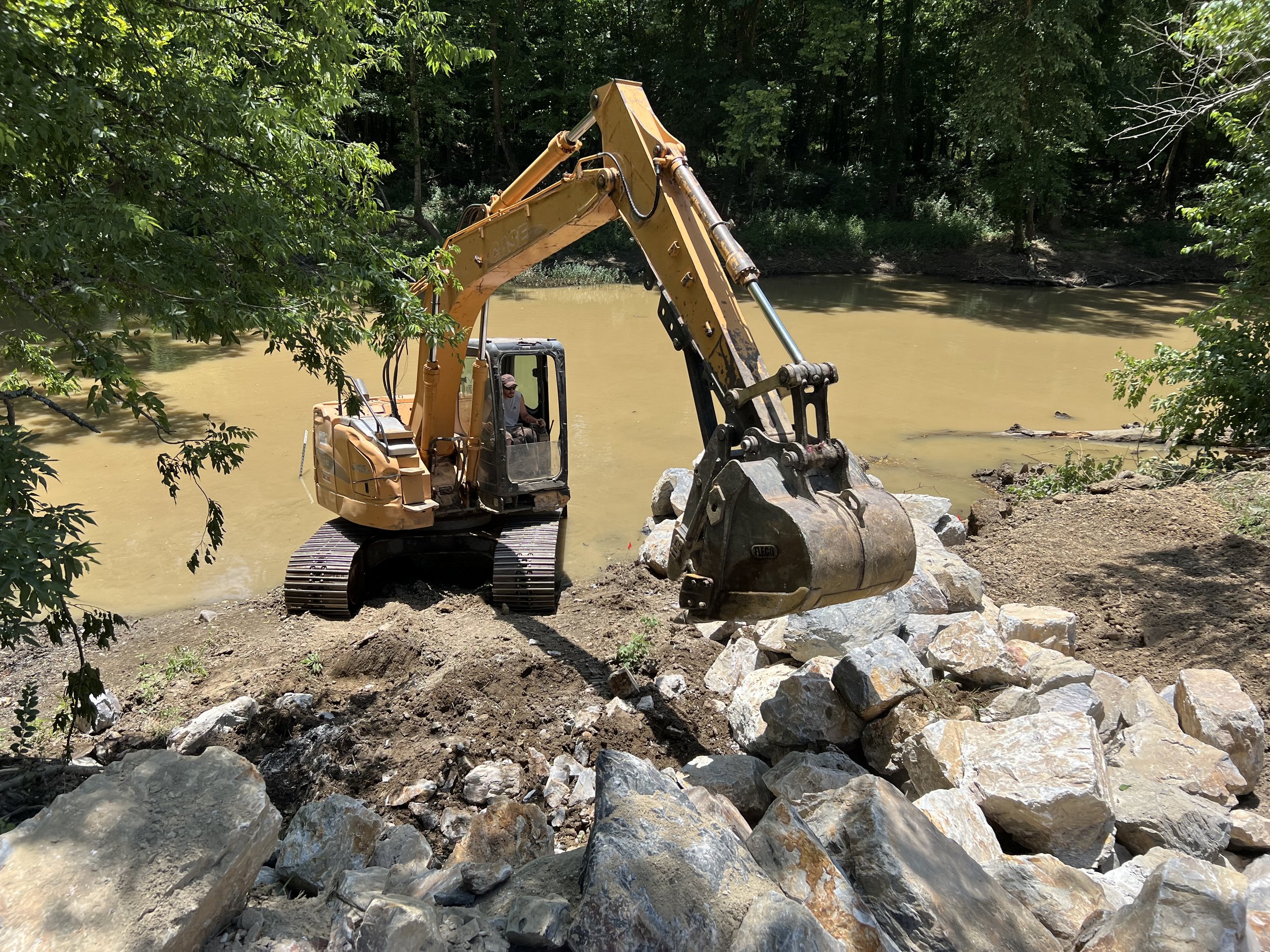
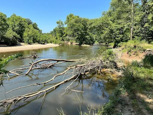
Star Valley Farm - Completed Summer 2024
The property is located on the North Fork Saline River approximately 5 miles northwest of Benton, Arkansas in Saline County. The project site is an actively eroding streambank on the left descending bank. At the time of the site visit, the area of concern was 428 linear feet long with 9-10 foot high vertical banks.
-
This property is owned by Clark and Carrie McWilliams. The property is located on the North Fork Saline River approximately 5 miles northwest of Benton, Arkansas in Saline County. The project site is an actively eroding streambank on the left descending bank. At the time of the site visit, the area of concern was 428 linear feet long with 9-10 foot high vertical banks. The riparian area on the right descending bank is in good condition with a mixture of age classes of trees, shrubs, vines, and perennial grasses. The main cause for streambank erosion at this site is due to many years of livestock grazing the riparian vegetation and the livestock trampling the streambanks. Another major contributor for erosion at this site, is the morphology of the stream channel, a sharp s-curve with 90 degree bends, directing the flow of water directly into the streambank.
The primary soils are Ouachita silt loam, which are very erodible and frequently flooded. The frequency and magnitude of floods that we have encountered in recent history have also caused a lot of the damage. With each major flood event, literally tons of soil/sediment is sent down the Upper Saline watershed which is home to federally listed threatened Arkansas Fatmucket (Lampsilis powellii), endangered Pink Mucket (Lampsilis abrupta), threatened Rabbitsfoot (Quadrula cylindrica cylindrica), and endangered Winged Mapleleaf (Quadrula fragosa) freshwater mussels. The North Fork Saline River is a state designated Extraordinary Resource Waterbody (ERW), and an Ecologically Sensitive Waterbody (ESW) for the endemic Ouachita Madtom (Noturus lachneri). Also contained within this river is a favorite sportfish for many anglers, the Smallmouth Bass (Micropterus dolomieui).
The recommended methods for stabilizing this eroding streambank are constructing rock vanes, installing permanent livestock exclusion fencing, providing an alternative water source for the livestock, and replanting native vegetation to re-establish a healthy riparian buffer.
The rock vanes will direct the flow of water away from the eroded bank back to the center of the stream channel. The flow of water directly upstream of each vane (in the notch of the vane) and downstream of the vane (energy shadow) will slow down and lose its ability to carry materials (sediment) within the water column; therefore depositing it next to the bank in the notch of the rock vanes and below the rock vanes. Over time this area will fill in with silt, sediment, and seeds and re-vegetate naturally.
Four rock vanes, approximately 60 feet long each, will be installed to adequately protect thistreambank. Each vane will be keyed into the bank 20 feet for stability and to prevent the structure from being flanked during a flood. The vanes will point upstream at a 30 degree angle from the shoreline. The vanes will be approximately 6 feet tall at the streambank (approximately 1 foot above the ordinary high water mark (OHWM)). The surface slope of the vane arm will be 10:1. The tip of each vane will be buried into the streambed approximately 3 feet. The largest rocks that are delivered will be used to build the base of the vane and used to construct the tip of the vane. If bedrock is encountered, the tip rocks will be "nailed or pinned" down with 1 inch steel round rod to anchor them in place. Construction will start downstream and work upstream. All rocks will be placed in compression with the flow of water to prevent them from shifting or becoming loose. Rock will also be placed in a rip rap fashion between the two upstream vanes. Locally obtained quarried rock, with a "B" axis ≥ 24 inches, will be used to construct the vanes and for the rip rap between the two upstream vanes. Construction for this project will be conducted during low flow conditions.
All bare soil disturbed during construction will be seeded with grasses appropriate for the time of year and ecoregion. During the dormant time of year, native trees, shrubs, and grasses will be planted on a 9' x 9' spacing on the high bank and extend out into the floodplain at least 60 feet to re-establish a healthy riparian corridor.
A permanent 5 strand barbed wire fence will be built 60 feet out from the high bank to protect the riparian buffer. An alternative water source for the cattle will be built to provide drinking water away from the North Fork Saline River. Details on what type of watering facility are still to be worked out with the landowner and possibly the Natural Resources Conservation Service (NRCS).
These techniques have worked very well on other similar sites throughout the state. The combination of practices mentioned above will keep the torrent (a.k.a. fast flowing water) off of the eroding bank, reducing near bank shear stress and creating friction to slow flood waters down; therefore reducing velocity on the flood plain and increasing deposition, which ultimately will stop lateral migration due to streambank erosion.
This project was completed Summer 2024 with multiple funding sources. Below are before and after pictures.


Buckhorn Ranch LLC. Project - Completed October 2019
The project site is an actively eroding streambank on the right descending bank. The cause for streambank erosion at this site is difficult to determine because the riparian zones are very well intact.
-
BuckHorn Ranch LLC Project
This property is owned by Brian Nalley and is located on the Alum Fork Saline River approximately 8 miles west of Benton, Arkansas in Saline County. The project site is an actively eroding streambank on the right descending bank. The cause for streambank erosion at this site is difficult to determine because the riparian zones are very well intact. I do know that Ouachita silt loam soils are highly erodible and the frequency and magnitude of floods that we have encountered in recent history have caused much of the damage. With each major flood event, literally tons of soil/sediment is sent down the Upper Saline watershed which is home to federally listed threatened Arkansas Fatmucket (Lampsilis powelli), endangered Pink Mucket (Lampsilis abrupta), candidate species Rabbitsfoot (Quadrula cylindrica), and endangered Winged Mapleleaf (Quadrula fragosa) mussels. The Alum Fork Saline River is a State designated Extraordinary Resource Waterbody, and is Ecologically Sensitive for the endemic Ouachita Madtom (Noturus lachneri).
At the time of the site visit, the area of concern was 1,225 linear feet long with 15 foot high vertical banks. Primary soils are Ouachita silt loam, and it is frequently flooded.
The recommended methods for stabilizing this eroding streambank are constructing rock vanes that point upstream, and replanting native vegetation. The rock vanes will direct the flow of water away from the eroded bank back to the center of the stream channel. The flow of water directly upstream of each vane (in the notch of the vane) and downstream of the vane (energy shadow) will slow down and lose its ability to carry materials (sediment) within the water column; therefore depositing it next to the bank in the notch of the rock vanes and below the rock vanes. Over time this area will fill in with silt, sediment, and seeds and re-vegetate naturally.
Eight rock vanes, approximately 80 feet long each, will be installed to adequately protect this streambank. Each vane will be keyed into the bank 20 feet for stability and to prevent the structure from being flanked during a flood. The vanes will point upstream at a 30 degree angle from the shoreline. The vanes will be approximately 8 feet tall at the streambank with a surface slope of 10:1. The tip of each vane will be buried into the streambed approximately 3 feet. The largest rocks that are delivered will be used to build the base of the vane and used to construct the tip of the vane. If bedrock is encountered, the tip rocks will be "nailed or pinned" down with 1 inch steel round rod to anchor them in place. Construction will start downstream and work upstream. All rocks will be placed in compression with the flow of water to prevent
them from shifting or becoming loose. See project design diagrams for more detail. Locally obtained rock, with a "B" axis ≥ 24 inches, will be used to construct the vanes.
Construction of rock vanes for this project will be conducted during low flow conditions.
Any and all bare soil disturbed during construction will be seeded with grasses appropriate for the time of year and ecoregion. During the dormant time of year, native trees, shrubs, and grasses will be planted on a 9' x 9' spacing on the high bank and extend out into the floodplain at least 60 feet to re-establish a healthy riparian corridor.
These techniques have worked very well on other similar sites throughout the state. The combination of practices mentioned above will keep the torrent (a.k.a. fast flowing water) off of the eroding bank, reducing near bank shear stress and creating friction to slow flood waters down; reducing velocity on the flood plain and increasing deposition, which ultimately will stop lateral migration due to streambank erosion.
Completion of this project involved multiple State and Federal agencies for permits, cultural, ecological and aquatic surveys, grant and private funding. Private contractors and businesses were used to supply material, equipment, and horticulture supplies. After completion of the project in October 2019 the bank erosion ended and additional aquatic habitat had begun taking shape.
Below is a link to the Arkansas Game and Fish Stream Team project documentary and pictures of before and after completion.


Get in touch.
If you’re passionate about the Saline River Watershed and want to get involved, we’d love to hear from you! You can reach us by sending an email with form below.